
Towton Battlefield
The small village of Towton is situated four kilometres to the south of the market town of Tadcaster and 18 kilometres southwest of the city of York, the medieval secular and ecclesiastical centre of northern England.
This small medieval hamlet gave its name to what is regarded as the largest battle ever fought on British soil, with over 100,000 combatants allegedly taking part and approximately 28,000 dead (English Heritage 1995). The Battle of Towton took place on Palm Sunday, 29th March 1461 between the armies of King Henry VI of the house of Lancaster and Edward Earl of March, later Duke of York, of the house of York. Preceding the battle Edward had been proclaimed the new king, and after his victory at Towton he was crowned King Edward IV.
However, although much has been written about the battle, most of it is based on surprisingly little primary historical resources. Secondary historical documents, mainly eighteenth, nineteenth and twentieth century works, e.g. Drake (1736), Leadman (1891) and Boardman (1996) reiterate and embellish the earlier sources whilst adding local legends and folklore.
In 1996 a team of builders, working on an extension to Towton Hall in Yorkshire found human remains.
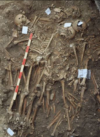
The most tangible evidence for the battle came from the excavation of a mass grave containing the remains of approximately 50 individuals, which was excavated and recorded during building work at Towton Hall. A radiocarbon date (Fiorato et al 2000) confirmed that the skeletons were contemporary with the battle. Detailed analysis of the excavated material revealed that all individuals were males who had suffered extensive trauma, inflicted by swords, knives, bills, and war hammers. The published results created considerable interest and even led to a successful television documentary.
Following on from these initial findings it was decided to start an extensive landscape survey project to reveal further archaeological evidence from the battle. As most of the field boundaries from the period had been removed and other landmarks connected with the battle destroyed, it was clear from the outset that the integration of several site assessment techniques was required to draw meaningful conclusions. The project therefore relies on the re-analysis of existing data from the North Yorkshire County Council Historic Environment record (HER – the former Sites and Monuments Record -SMR), maps and aerial photographs, and the collection of new data through geophysical surveys, field walking and dedicated metal detector searches.
Project Director: Tim Sutherland
Web Master: Simon Sutherland